WILLEMSTAD – Curaçao experienced a warmer and significantly drier August than usual, with temperatures above the long-term average and rainfall at Hato reaching only a fraction of what is normally recorded during the month.
According to the monthly climate overview from the Meteorological Department Curaçao, the average temperature at Hato in August 2026 was 29.7 degrees Celsius. The long-term average for August, based on the 1991–2020 reference period, is 29.1 degrees.
Last month was also slightly warmer than August 2025, when the average temperature at Hato was 29.5 degrees.
The most striking difference, however, was rainfall. Only 5.7 millimeters of rain was measured at Hato during August, compared with the normal monthly average of 27.7 millimeters. In August 2025, Hato recorded 22.6 millimeters.
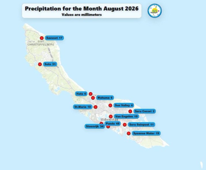
Rainfall varied considerably across Curaçao. Parts of the north coast received between 6 and 19 millimeters, while considerably higher amounts were measured elsewhere on the island.
Punda recorded 48 millimeters of rain, followed by Steenrijk with 34 millimeters and Soto with 31 millimeters. Spaanse Water and Van Engelen each received 19 millimeters, while Seru Cocori recorded just 2 millimeters.
Wind speeds were also slightly above normal. Hato registered an average wind speed of 11.9 knots, compared with the long-term August average of 11.4 knots. In August 2025, the average was 10.4 knots.
According to the Meteorological Department, the warmer and drier pattern is likely to continue in the coming months. The outlook is linked to the presence of El Niño conditions.
As a result, Curaçao is expected to receive below-normal rainfall while temperatures are likely to remain above average, extending the warmer and drier conditions experienced in August.