THE HAGUE – The Kingdom of the Netherlands has taken another step toward formally establishing its maritime boundary with Saint Kitts and Nevis, following the submission of a treaty approval bill to the Curaçao Parliament. The agreement covers approximately 140 kilometers of maritime boundary southwest of Sint Maarten and west of Sint Eustatius.
Governor Mauritsz de Kort forwarded the proposed legislation to the Curaçao Parliament on November 4, 2026, as part of the constitutional approval process required before the treaty can enter into force.
The agreement was signed on April 4, 2024, in Basseterre, the capital of Saint Kitts and Nevis, following negotiations that began in 2013 and were completed in 2014.
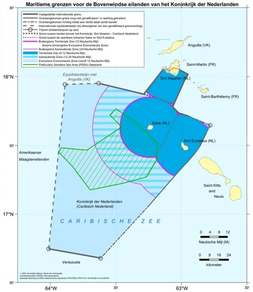
Despite the relatively quick conclusion of negotiations, nearly a decade passed before the treaty was formally signed. The delay was partly attributed to internal decision-making procedures within Saint Kitts and Nevis.
The agreement establishes the precise maritime boundary between the territories of the Kingdom of the Netherlands and Saint Kitts and Nevis.
Clearly defined maritime borders are important for determining jurisdiction over fishing activities, protecting the marine environment, and regulating potential exploration and extraction of offshore oil and natural gas resources.
The Executive Council of Sint Eustatius was consulted during preparations for the agreement because of the island's geographical proximity to the maritime area concerned.
The newly agreed boundary forms part of the so-called Windward Islands maritime boundary network, commonly referred to as the Bovenwindse Box.
This network consists of maritime boundaries surrounding the Kingdom's northern Caribbean islands and is intended to provide legal certainty regarding the division of maritime areas between neighboring countries.
The new boundary connects in the north with the existing maritime delimitation involving France near Sint Maarten and in the south with the maritime boundary established between the Kingdom of the Netherlands and Venezuela in 1978.
One notable aspect of the agreement concerns an objection raised by Saint Kitts and Nevis regarding part of the existing maritime boundary between the Kingdom and Venezuela.
Saint Kitts and Nevis has not accepted that portion of the earlier delimitation. As a result, the new treaty contains specific legal wording designed to ensure that Saint Kitts and Nevis is not considered bound by the previously established boundary between the Kingdom and Venezuela.
This provision allows the two countries to establish their own maritime boundary without requiring Saint Kitts and Nevis to recognize the legal implications of a separate agreement to which it was not a party.
The treaty also addresses the possibility of oil or natural gas deposits extending across both sides of the newly established maritime boundary.
If such deposits are discovered, the countries involved will be required to consult with one another regarding their development and potential exploitation.
These provisions are intended to prevent disputes over resources that may extend across national maritime jurisdictions.
According to the information accompanying the treaty, no such cross-border oil or gas deposits are currently known to exist in the area concerned.
The agreement represents another step toward completing the maritime delimitation of the Kingdom's territories in the northeastern Caribbean.
However, not all maritime boundaries in the region have been finalized.
The Kingdom of the Netherlands is still negotiating with the United Kingdom regarding the maritime boundary near Anguilla and with the United States concerning the boundary near the U.S. Virgin Islands.
Completing these negotiations would provide greater legal clarity over maritime jurisdiction in the waters surrounding the Dutch Caribbean islands.
The treaty approval bill was previously submitted to the Dutch House of Representatives in The Hague on October 20, 2026.
Because the agreement concerns the Kingdom as a whole, its approval requires the applicable parliamentary procedures before it can formally enter into force.
The submission to the Curaçao Parliament forms part of that process and provides the island's elected representatives with an opportunity to examine the agreement and its implications.
Although the maritime boundary concerned lies far from Curaçao itself, the treaty falls within the broader framework of the Kingdom's international responsibilities and maritime relations.
For Sint Maarten and Sint Eustatius, the agreement has more direct geographical significance because it concerns neighboring maritime areas.
Once the necessary approval procedures have been completed and the treaty enters into force, the approximately 140-kilometer boundary will be formally established under international law.
The agreement is expected to strengthen legal certainty in the region and provide a clearer framework for maritime activities, environmental protection, and any future offshore resource development.